A Map in Progress: Integrating Technology in Early Literacy
Posted June 15, 2015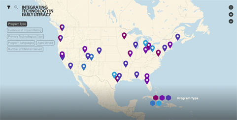 Integrating Technology in Early Literacy (InTEL) Map


This post is one of the more than 20 articles that appeared as part of a series called Seeding Reading, first published in 2014-15 on the EdCentral.org blog at New America and on the Joan Ganz Cooney Center blog.
Today, young children have access to more technology than ever, and families of almost all socio-economic backgrounds are making smartphones and other internet-enabled devices part of their daily lives.Many early education programs around the country are beginning to determine how they might harness these tools to engage with parents, improve home-to-school connections, and otherwise augment efforts to help children develop early language and literacy skills.
Last week, New America and the Joan Ganz Cooney Center at Sesame Workshop launched an interactive map showing where these programs are located, how they are going about their work, and what evidence of impact they are able to share. We presented the map (see image below), which is still “in beta,” at CGI America, an annual meeting of the Clinton Global Initiative, in Denver last week. The map provides a birds’ eye view of innovation around the country, and is designed to enable users to sort initiatives by type of program, technological tool, evidence of impact, age of children served, and more. Clicking on the pindrops for each program opens a new page with a profile of the program including narratives, submitted by the programs, on how they got started and why.

We have named this mapping project InTEL: Integrating Technology in Early Literacy, and are already hearing positive feedback from state and program leaders who have been testing new approaches and need to be able to see the landscape and find examples with a solid research base. We encourage you to click around and take a look as we improve the map and profiles over the summer and let us know what you think. This data collection, which started with a survey in February, has now been re-opened and our teams will be adding information to the map on a rolling basis through the end of September. If you represent a program that you think should be included in our database, please complete our survey.
Please note: This map does not attempt to categorize products, such as websites, curated collections, subscription-based online libraries, apps, or ebooks. We are focusing instead on interventions, pilot initiatives, programs and other activities pursued by educators and community leaders.
The beta version is supported by The Alliance for Early Success, a catalyst for bringing state, national, and funding partners together to improve state policies for children, starting at birth and continuing through age eight, and by the Pritzker Children’s Initiative. The project was born in an early childhood working group meeting at CGI America in 2014, was announced during presentations at the White House event on “Bridging the Word Gap,” and was highlighted as an upcoming project at the White House Summit on Early Learning last year.
The InTEL map is a part of a larger data platform called Atlas, which is being developed by New America’s Education Program. It will house different data visualizations, maps, and other interactive displays of our research and policy analysis. A beta version of the platform was published in June 2015.
Stay tuned for more information about an official release of the InTEL map and an overview of its findings this fall.


